The Saltee Islands

Back when I started this blog three years ago, the Saltee Islands was one of the places I was really excited to see.  However, due to its distance from other sites I was interested in and the potential difficulties in reaching it, I quickly cut it from our planned 2016 itinerary.  But it’s still an interesting place worth considering, especially if your travels take you to the region.

The Saltee Islands, both Greater and Little, are located about 5 kilometers (3 miles) off Wexford’s coast and are best known for their resident sea bird populations.  Like the Cliffs of Moher, they provide ideal nesting habitat for over 200 species, including gannets, manx shearwaters, and puffins.  The Greater Saltee was also home to a bird observatory from 1950-63, allowing ornithologists to gain valuable information about Ireland’s migratory seabirds.

But seabirds aren’t the only sight found here.  The island serves as one of only a few breeding sites for grey seals in Ireland, with up to 20 pups born each year.  Visitors can also catch glimpses of whales and other marine life in the waters around the island, making it an interesting stop for nature lovers of all ages.  And with traces of forts and other structures from its thousands of years of human activity, there’s something to see for just about everyone.

The main reason I’m hesitant to plan on seeing the Saltee Islands is simply the task of getting there.  Although the visitor’s information page says nothing about a charge to step foot on the island itself, it clearly states trips must be arranged from Kilmore Quay, with no recommendations to contact.  Scrolling through TripAdvisor leads me to believe many people wait until they’re in Kilmore to charter a boat, though several people recommended Declan Bates, the only person I’ve found a definitive price for who will take you directly to the island.  The cost is 30 per person, and it’s best to remember there aren’t toilets or man made shelters on the island, so the four hour stay on the island can be unpleasant if the weather turns bad.

Alternatively, I did find one charter tour that loops around the islands for 20 per adult and 10 per child, with whale watching trips also available.


Additional Links & Resources:

Delan Bates – Boating Charter information

Discover Ireland:  Saltee Islands

The Golden Book:  Ireland, page 47

Kilmore Quay Angling Charter “Karen Ann” – Saltee Islands

The Saltee Islands official website

An Irish Survival Guide – Getting Around Ireland

My mother and I enjoy talking about the different sites we visited while in Ireland, but occasionally, we also just shake our heads at the things we wish we’d known ahead of time, before arriving and starting our adventures.  Thus came the idea of creating an Irish Survival Guide – a collection of all we’ve learned so far through research and first-hand experiences, to hopefully save other travelers from making some of our mistakes.

First up comes a fairly big part of exploring Ireland:  getting around the country, and figuring out what rental car is best for you.

As a note, I’m all for tour groups, too – they’re a wonderful way to take in a large swath of the country and can give you peace of mind because you won’t be the one responsible for driving after a long day of sight seeing.  But self-guided tours are definitely the way to go once you step off the well-beaten tourist track, allowing you to venture to regions buses simply can’t go due to their size.  Keeping this in mind (small car = increased accessibility to more sites), here’s my survival guide for renting a car and driving in Ireland. 

enniskerry-road

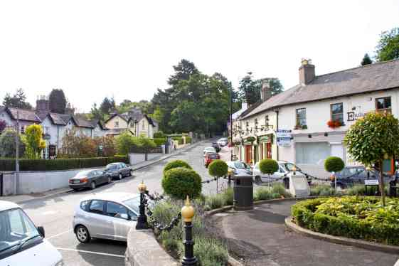
The main road running through Enniskerry’s center square is a pretty good example of how roads look in Ireland’s smaller towns.  From my 2011 trip.

Familiarize yourself with Ireland’s road classifications

This is something we learned very quickly on our second trip.  The differences between road types in Ireland can be stark, so it’s best to know what you’re getting yourself into before you take what sounds like the perfect shortcut.

Motorways, or M routes, are the widest, most accessible roads.  Their speed limits are high – 120km/hr (75 mph) – and they’re generally double lanes.  Areas to pull off the road and stretch for as long as you need are fairly common and easier than finding a filling station off an interstate would be in the US – they almost make me think of the pit stops you’ll see on racetracks, just a gentle drag off the main road.

Unfortunately, you’ll most likely spend only a short fraction of your trip on the M routes.  National (N) roads are far more common, but trickier to maneuver.  Speed limits are up to 100km/hr (about 62 mph), but don’t expect to travel that fast, especially not at first!  These roads are much narrower than M routes, sometimes to the point you’ll wonder how two cars are supposed to meet without crashing.  Corners are often sharp and blind, especially with Ireland’s thick hedges.  Yet roads can get narrower still.

Enter the Regional (R) roads.  These are the stuff of nightmares, but what you’ll be spending a lot of time navigating if you’re interested in seeing megaliths and other remote sites.  Hedges are thicker, roads are smaller, yet the speed is still uncomfortably high – 80km/h (50 mph).

r-road

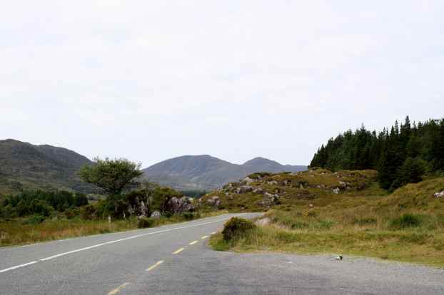
A pretty good example of what an R road looks like.  Thankfully, we didn’t go down this one in 2011.

I’m a country girl, used to Missouri’s winding backroads and dirt “roads” through fields on the farm.  But Ireland’s R roads left me baffled.  There’s no way you can drive that fast on those things!  Especially since they’re still two-way traffic roads, most of the time.  In some of our travels, we literally had to stop with the windows open to listen for other cars coming before turning out of blind side roads, because there was no way we could see anything coming.  Yes, what we saw by taking these roads was well worth the time and effort, but just remember – R roads are not shortcuts.  You will not gain time by leaving an N road or M route to take what looks like a shorter stretch of R roads.

Google Maps’ travel times are straight up lies

This is probably one of the most important things to know before you start planning your itinerary.  We were told on our first trip to Ireland, where neither of us had to drive, that Ireland is simply 6 hours from northernmost point to southernmost point, and 4 hours across.  With that in mind, and Google Maps’ estimated travel times, we didn’t see any harm in planning a fairly spread out route for our second trip.

However, we had no real idea what the roads would be like – our driver couldn’t take us down any R roads because of the bus’s size, and quite frankly, who really pays attention to road conditions when someone’s driving for you like that?  Especially when you know you won’t be back for several years at the very least?

Google Maps is a wonderful tool, especially when you’re in the early planning stages, but it assumes you’ll be driving at the posted speed limit, or at least close to it.  It doesn’t account for nerves when getting used to driving on the opposite side of the road, or the learning curve that comes with navigating those narrow roads.  Or how it’s physically impossible to drive that fast on an R road as a tourist without having a heart attack. (Note:  I might be a bit prejudiced against R roads.)

A good rule of thumb we learned from a local taxi driver in Killarney is that you should double or triple the travel time Google Maps gives you.  And he was right – even the fairly straightforward drive from Killarney to Galway, a 2 hour, 38 minute drive by Google Maps using N roads and an M route, took us around six hours.  Not pleasant in the slightest!

lies

A map of lies…

Plan ahead to get lost and to travel slow, and remember this when planning accommodations.  Because we didn’t know this before reserving rooms, we constantly arrived several hours later than planned, often barely finding time to eat before places started to close for the night.

Investigate your options for rental car insurance or CDW thoroughly

It’s probably not surprising, given Ireland’s narrow roads and thick hedges, that most credit cards won’t offer rental car insurance within the country.  Instead, many car rental companies offer what’s called CDW, or a collision damage waiver.  It’s often factored into the rental price quoted at you, and means that the rental company won’t collect fees against you for damage done to the vehicle – to a certain point.  Basic CDW agreements generally leave the renter at risk for covering the first $1-$2k in damages, something that could leave you a nervous wreck on some of the more treacherous roads.

But there are other options.  My mother and I rented from Dan Dooley, and though I’m afraid I don’t remember the exact name of the coverage we purchased since it was part of a bundle,I know it was better than the basic CDW – as long as we didn’t lose the key or put the wrong kind of gas in the tank, we didn’t have to worry about any damage done to the car.

Definitely call ahead of time to learn exactly what you’re paying for, both so you’ll not be faced with surprise charges down the road and so you’ll secure a better rate than you’d be quoted at the pick up desk.

Consider driving diesel

I know this one probably sounds pretty odd, considering how diesel fuel is constantly higher than unleaded in the States, but there’s sound logic here that my mother and I learned first hand.  Diesel cars are often more fuel efficient than their counterparts, meaning you can go farther on less gas, saving you both time and money.  But remember – gas pump colors are not the same as they are in the States, they’re reversed.  Always check that you’ve picked up the right pump before you start refueling to avoid damaging the car.

motorway

Another quick shot from 2011, showing what M routes typically look like.

If your car seems to stall every time you break for a few seconds, don’t panic!

This is another big one I wish we’d known ahead of time.  Like many people, my family primarily drives older cars in the States.  So, when our car seemed to cut out and stall every time we came to a stop in Dublin’s city centre, we panicked, assuming something was wrong.

Thankfully, as our rental company confirmed with a quick phone call, this was completely normal – some cars in Ireland are fitted with a new “stop-start” system that helps conserve fuel and reduce emissions when a car’s stopped for more than a few seconds.  Simply releasing the break and tapping the gas gets the engine to going again, and there’s often a button on the console to prevent this feature from kicking on if it does give you undo tension, like it did for us.

Farm equipment always wins

This might seem like an odd side note, but it’s one that left my mom and I staring.  Farmers are the kings of the road, and everyone defers to them, even larger trucks.  If you meet a tractor on a road too narrow to pass side by side, you’re expected to either find a way to pull over or back up until they can pass you.  Our tour guide from our first trip said the same’s expected when a car meets a bus, and meeting either is equally terrifying.

ALWAYS have an Irish roadways map with you, even if you have a GPS.

I honestly can’t remember how many times our GPS got us helplessly lost while looking for megaliths around the Irish countryside.  We’d opted to upgrade our own GPS to include Irish roads, in the hopes of avoiding a steep learning curve with a new device, but it didn’t matter – we still ended up stuck in the middle of nowhere time after time.  The worst time this happened was somewhere in Meath, while trying to track down Fourknocks.  Even with directions from another blogger, and two stops to ask locals for directions, we somehow ended up on a road so degraded there was more grass than pavement.  And when we turned to the GPS to even tell us where we were, so we could use the map to find our way back to a major highway?  The blasted thing said our location was unknown – it couldn’t even give us our coordinates.

kerry-road

The road we took into Killarney back in 2011.  Areas like the Gap of Dunloe were even narrower – I don’t advise driving on those, even when it is allowed.

If you do rely on a GPS and get lost, use its points of interest feature to help orientate yourself

We never did find Fournocks.  After cringing with each scrape and bump from our car’s undercarriage on that road, we decided we had to find some way back to the main roads.  My mom realized that, even though our GPS couldn’t tell us where we were, it could direct us to the nearest Garda (police) station.  We used our map, the rough area we knew we had to be in, and that GPS feature to slowly but surely find our way to the larger N roads.  Without it, I honestly don’t know how long we would have spent driving in circles, just hoping to find a sign pointing us in the right direction.

Before you set out, check your GPS settings

This is probably one of the top things I wish we’d known before leaving Dublin on day 1.  Because we’d never had issues with our GPS back home, we never imagined settings could change when we used an Irish road map extension.  In the States, our GPS is set to find the quickest route, regardless of traffic flow.  But on our last night in Ireland, we discovered the settings had somehow been tweaked to make our GPS seek out the least traveled roads available.  Suddenly everything made sense – why we ended up lost in Leitrim on our way to Northern Ireland, how we ended up driving in circles around Ahenny’s high crosses and Jerpoint Abbey, why we got lost in Sally Gap when there was an N road that lead straight to Glendalough.

sally-gap-road

One of Sally Gap’s narrow stretches.  This road became even more nerve wracking anytime it veered near the edge of a sheer drop.

Had we checked our GPS settings before setting out, we probably could have saved a lot of time and frustration during our trip.  Yet, at the same time, by getting lost so frequently, we did get to experience parts of Ireland we wouldn’t have seen otherwise.  It’s anyone’s guess which would have been truly best, though perhaps it’s safe to say that you can get a taste of both by investigating scenic routes in the region you’ll be exploring, then weigh out your options based on how that day’s gone up to that point.  At least then you won’t be entirely at the mercy of your GPS’s whims.


I’d originally planned to combine these tips in a single post, but as the list grew, I realized it would be more manageable as a series.  Keep a look out for future guides, such as money tips and ways to get a true taste of Ireland’s culinary offerings.

And please, if you have any questions or suggestions for future blog posts and guides, let me know!

Fourknocks Megalithic Tomb

Amongst the various megaliths we’d plan to see on our trip in 2016, Fourknocks was probably one of the most remote.  Since its tucked away in the Boyne Valley region like Loughcrew, it made sense to see both at the same time.  However, with GPS difficulties rearing its ugly head again, our plans were quickly dashed and we gave up, ready to reach our bed and breakfast in Kells.

fourknocks-aerial

Aerial view of Fourknocks.  Image Credit:  Knowth.com

Dating back around 5,000 years, Fourknocks (from Fuair Cnocs, or “”Cold Hills”) is another example of a cruciform passage tomb with its short entry passage, big central chamber, and three smaller side chambers.  At 42 square meters (around 452 square feet), its central chamber is more than double the one found at Newgrange, and it’s probably for this reason the original tomb lacked the roof seen today.  Its believed that, if anything, Fourknocks had a wooden roof supported by a central pole.

The National Museum excavated the site from 1950-1952 and found numerous human remains of all ages and sexes.  Grave offerings were also found, and are now in the side chambers, and are now on display at the National Museum.  After the excavation was complete, the dig team created the current roof from concrete.  Some holes were left to allow sunlight to filter through, illuminating the different carved designs.

fourknocks20face

Carving believed to be the first depiction of a human face in prehistoric Irish art.  Image credit:  Megalithic Ireland.

Fourknocks is only 10 miles southeast of Newgrange, and the two sites are actually in alignment with each other. But unlike Newgrange, Fourknocks is not illuminated during the winter solstice; though in line with the sun’s path, it’s too far north for any light to enter its chamber.   The site did once align with an astrological feature however.  Astronomers know that, when Fourknocks was built, Cassiopeia’s “W” shape would have been in perfect alignment with the four mounds.  It’s been suggested this is why a “W” motif commonly appears in the site’s carved stones, and that perhaps the roofless design was intentional for stargazing.

fourknocks2002s

Lintel stone with “W” motif.  Image Credit:  Megalithic Ireland.

Directions to the site can be very complicated, especially since signs telling you where you are aren’t very common.  But if you can find it, Fourknocks is said to be a wonderful, secluded site.  The mound is on private property, so visitors need to stop by Mr. Fintan White’s house roughly 800 meters away from the tomb to get a key.  He asks for a 20 euro deposit, to ensure you’ll bring the key back before 6pm, and his phone number is easily found across various websites.  Perhaps I’d written the number down while preparing for our trip, but I was unable to reach him.  If you do try calling him, I wish you better luck!  The number is 353 (0) 1 8354722.

OLYMPUS DIGITAL CAMERA

Front view of the main mound.  Image Credit:  Knowth.com

I definitely still would love to see Fourknocks someday, though I’m a bit wary of trying to find it on my own after our experience.  Since coming back to the States, I have found private tours of the site, including other Boyne highlights, exist.  But the price is steep – €380 after a direct booking discount, for 1-3 people through Boyne Valley Tours.  Mythical Ireland offers tours as well, though they do not quote a price on their website.

Still, it might be worth considering, depending on what other sites could be combined with Fourknocks for this personalized tour.  Avoiding the nerve-wracking hunt for the site would definitely be a nice refresher!


Have you been to Fourknocks?  If so, what do you think, and do you have any tips for someone like myself who had difficulty finding the site?


Additional Links & Resources:

Boyne Valley Tours: Fourknocks

Directions to Fourknocks

Knowth.com – Fourknocks

Meath Tourism

Megalithic Ireland

Mythical Ireland

The Giant’s Causeway

As I mentioned in my last post, my family and I went to the Giant’s Causeway with our tour group back in 2011.  As was the case at Dunluce Castle, the views of Antrim’s rugged coastline were spectacular, though because of the Causeway’s nature, we were able to get a lot closer to the water’s edge.

causeway2

The Giant’s Causeway is a modern day UNESCO World Heritage site, but its natural beauty has drawn in visitors for centuries.  Its iconic hexagonal basalt stacks were formed by rapidly cooling lava 60 million years ago, but that hasn’t stopped the human imagination from coming up with other theories for their existence.  Some of the first visitors believed it had to be the work of men armed with picks and chisels or even Finn McCool, giant and hero of the Fenian Myth Cycle.

Finn McCool is described in many different myths, but one of the first I heard was of his role in the Giant’s Causeway’s creation.  The story goes that Finn and the Scottish giant Benadonner hated one another, and after another day of exchanging insults, Finn tore up chunks of land to build a stepping stone path to reach Benadonner.  The latter quickly destroyed the path, separating the two countries once more and creating what we know today as the Giant’s Causeway.  Interestingly enough, the same basalt pillars can be seen in Scotland, too, on the Isle of Staffa.

Finn’s folkloric touch on the landscape can be seen in the names of different formations too, from the Giant’s Boot to the Wishing Chair, and the story of his fight with Benadonner is commemorated with a sign post at the main site.

causeway3

Of course, the Causeway also holds a special place in my heart due to a friendly argument my eldest sister and I still bring up every once in a while – whether or not to walk on the black rocks.

When our tour group arrived at the Causeway, we dispersed quickly.  I can’t remember exactly how it happened, but my sister and niece ended up well ahead of our parents and me, while the three of us took our time and kept pace with a few other people, taking in the sights and reading over the travel brochure.  The brochure mainly served as a map, for anyone interested in pushing past the main site, but it also offered a warning – don’t walk on the slick black rocks, closest to the water’s edge.  Signs along the path reiterated this – walking on the black rocks made it easy to slip and fall, possibly into the ocean’s hard surf.

Then one of the people in our makeshift group noticed two small pink dots, way off in the distance, right on the black rocks.

blackrocks

Guess who?

We jokingly pretended we didn’t know who those people could possibly be, though we knew right away from the raincoats it was my sister and niece.  And soon enough they wandered back our way, joining us up on the path to the main site with a laugh about not seeing any signs warning about the black rocks, insisting the warnings just weren’t there.

Even with the warnings though, it ended up being perfectly fine to walk on the black rocks when we were at the Causeway.  The sea wasn’t as rough as it could have been, and we were careful to watch our step whenever we did wander closer to the water’s edge.  But it’s still a fun joke to bring up every now and then when we look back on the trip, especially since she still insists there were no signs.

causeway1

Our time at the Giant’s Causeway felt all too short.  We only had a few hours to explore and eat before getting back on the road, so we were confined to the main spread.  Even then, I would have loved to spend more time walking along the stacks, just reveling in what nature can do.

My mom and I both want to visit Scotland someday, to see the Scottish side of the Causeway at the very least.  By the sounds of it, if we went, we’d be in for a very different experience…

NTSDOGp00010 Dollar Glen

Isle of Staffa.  Image Credit:  The National Trust for Scotland.


The Causeway itself is open from dawn to dusk daily and is free to visit on foot.  However, if you wish to visit any of the facilities or park at the center, you will be charged an admission fee.  This fee is £9 for adults and £4.50 for children, but discounts are available by either booking in advance or arriving by public transit.  The visitor center itself opens at 9:00 am, with closing times varying by season.

A shuttle bus is also available on site, making runs between the main site and the visitor center.  I personally recommend walking at least one way of the trip, both to enjoy a slower pace and to cut down on costs – it’s £1 per adult and 50 pence per child, each way.


Additional Links & Resources:

Discover Northern Ireland: Giant’s Causeway

The Giant’s Causeway official guide

The Golden Book:  Ireland, pages 105-107

Ireland.com:  The Giant’s Causeway

Ireland Legends & Folklore, pages 34-35

The National Trust:  Giant’s Causeway

The National Trust for Scotland:  Staffa National Nature Reserve

Visit Scotland:  Isle of Staffa

Dunluce Castle

After getting helplessly lost while leaving Sligo, my mother and I were quite eager to get back to sight seeing.  Thankfully, our bed and breakfast in Portrush wasn’t too far away from our first site of the day, Dunluce Castle.  After a mere 15 minute drive down a road hugging Antrim’s beautiful coastline, we reached the castle before the large tour groups had begun to arrive.

castle4

Perched on one of Antrim’s cliffs, the castle has a very iconic look and has been called one of Ireland’s most romantic castles.  Parts of the castle were first built in the 1200s, but most of what remains today is much more recent – major additions were made through the 1600s.  But by the mid 1600s, the castle was abandoned by its last resident, the second Earl of Antrim, Randall McDonnell.  Story has it that in 1639, part of the kitchen fell into the sea during a storm, taking part of the kitchen staff along with it and prompting the Earl and his family to move first to Ballymagarry, then to Glenarm Castle when it was rebuilt in 1756.

castle3

Our time at Dunluce stood out most for its beautiful views of the ocean and Antrim coastline.  Since we arrived at the very start of the tourist season, the visitor’s center hadn’t gotten any postcards or brochures in yet, leaving us with little to go on aside from signs posted around the site.  I had downloaded a companion app for the site, but we found it more enjoyable just to take in the rugged beauty of the place and wander where we will rather than follow a structured tour path.

castle1

With a clear sky above and cool breezes coming in off the ocean, it was the perfect way to start another long day.  And though it was one of the busier sites we went to, it was easy to lose ourselves in both the moment and memories of our previous trip.  We’d seen a different part of Antrim then, with no idea how close we’d been to the castle – merely 15 minutes away, at the Giant’s Causeway.

castle2

Looking from the castle toward Portrush, where we’d spent the previous night.

Both sites are truly fantastic, and I highly recommend seeing them at the same time, if you can.  Along with the Carrick-a-Rede rope bridge and the Dark Hedges farther inland, they make a fairly nice cluster of sites that give a good sense of Antrim’s beauty.  But as a word of warning, plan on dedicating a full day to see them all – it’s a long drive back to the Republic.  My mother and I learned that the hard way.


Dunluce Castle is open daily from 10:00am onward, with closing hours varying from season to season.  Admission is £5 for adults and £3 for seniors and children.  The site also has a small tea room with bathrooms and souvenirs different than what you can find in the true visitor’s center.


Additional Links & Resources:

Discover Northern Ireland:  Dunluce Castle

The Golden Book:  Ireland, pages 107, 109

Parks & Gardens UK:  Dunluce Castle

The Cliffs of Moher

The Cliffs of Moher are probably one of Ireland’s most iconic sites and a true natural wonder.  With evidence of human activity stretching back at least two thousand years and the recognizable backdrop appearing in films such as The Princess Bride and Harry Potter and the Half Blood Prince, it’s easy to see why this landmark’s a must see for anyone exploring Ireland’s County Clare.

main-spread

North branch of the Cliffs, August 2011.

At their highest point, the Cliffs reach 214 meters (702 feet) before plunging straight down to the Atlantic Ocean.  But as one would expect from a signature point along the Wild Atlantic Way, the Cliffs are in a constant state of change – constant waves erode the mix of sandstone, siltstone, and shale at the Cliff’s base, causing higher levels to crumble and fall away.  For this reason, the very edge of the Cliffs is considered a protected area, and stone barriers have been erected to help prevent visitors from venturing too close to the edge.

The Cliffs are also home to mainland Ireland’s largest seabird colony, attracting thousands of pairs of breeding seabirds representing more than 20 species during the summer months.  Many of the seabirds have declining populations worldwide, further prompting sections of the Cliffs to be designated a protected area.  A worn footpath does extend past the barriers into this protective area, and visitors can cross over the barrier to reach it with little difficulty, but doing so is generally discouraged for both safety and conservation reason.

cliff-edge

The Cliff’s edge.  The dirt path on the left side of the shot is what we were walking on once past the barrier.

On the southern branch of the Cliffs, O’Brien’s Tower serves as a viewing platform.  Built in 1835 by Cornelius O’Brien in the hopes of bringing tourism to the area, the tower offers one of the best views of the Cliff’s northern branch, and on clear days, allows visitors to see as far as Connemara to the north and county Kerry to the south.

Hag’s Head, the Cliff’s southernmost point, is also visible from the tower, as is Moher Tower, built where a 1st century BC fort once stood.  It’s from this fort the Cliffs get their name – “mothar” means “ruined fort” in old Irish.

tower

View of O’Brien’s Tower from the Cliff’s Northern branch.

The hours my family spent at the Cliffs back in 2011 was definitely a highlight of our trip, even if the second half of our walk was nerve wracking for me.  I’m afraid of heights and prone to moments of vertigo, so when my family followed other tourists past the walled region of the cliffs to the protected area, I was a bit uneasy.

We didn’t push too far into the protected area, mainly due to time constraints, so I can only imagine what the views would have been like from farther out.  No matter how far we walked, the Cliffs stretched on and on, remaining hazy in the distance even though my telephoto lens.  And looking out at the Atlantic Ocean with its strong breezes, the Aran Islands clearly visible in the fair weather…  It’s a treat a landlocked midwesterner such as myself holds close to their heart, even long after the moment’s passed.

aran

Looking out at the Aran Islands from the Cliff’s North branch.

Admission to the Cliffs of Moher and visitor center is 6 for adults, but free for those under 16.  It’s an additional 2 for adults and 1 for children to visit O’Brien’s Tower on the south side of the cliff range.  The site is open year round from 9:00 am onward, with hours extending to 9:00 pm during July and August.


Additional Links & Resources:

Cliffs of Moher official site

Discovering Ireland:  The Cliffs of Moher

The Golden Book:  Ireland, pages 80-81

Ireland.com:  Wild Atlantic Way

The Wild Atlantic Way

Cahir Castle

Situated on a rocky island in county Tipperary, Cahir Castle is among Ireland’s largest and best preserved castles.

OLYMPUS DIGITAL CAMERA

Image Credit:  Irish Castles

First built in 1142 by Conor O’Brien, the castle replaced an earlier earthen fort that stood on the same site. Ownership of Cahir passed to the Butler family in the 13th century, who proceeded to expand and strengthen its defenses through the 15th century. The castle was captured three times over the course of its history, sometimes without a single shot fired.

p5090097ax_zpsophprjwt

Image Credit:  Irish Castles

Upon the last lord’s death in 1961, Cahir Castle became property of the Irish State. Multiple restorations have taken place since then, with an effort to remain faithful to the castle’s original design.

To celebrate the 100th anniversary of the 1916 Easter Rising, Cahir Castle also currently houses an exhibit over the Rising and War of Independence. The exhibit will remain in the castle’s great hall until September 30th.

cahir_zpsh1dozdb8

Image Credit:  Wikipedia

The castle has varying operating hours during the year. From March to mid-June, the site is open from 9:30 am to 5:30 pm. Hours are extended from mid-June to August, with visitors welcome from 9:00 am to 6:30 pm. Without a Heritage Card, admission is 4 euro per adult, 3 euro for seniors and 2 euro for children.  Guided tours are available, but must be booked in advance.

It’s also worth noting, the site only takes cash – no credit or debit cards will be accepted – so plan accordingly.


Additional Links & Resources:

Irish Castles: Cahir Castle

Heritage Ireland: Cahir Castle

Tourism Ireland: Cahir Castle

Irish Tourism: Cahir Castle

Carrowmore – Megalithic Cemetary of the West

Carrowmore, located just outside of Sligo, is Ireland’s largest megalithic cemetery. Some controversy surrounds how old the tombs at the site truly are, with dates ranging between 5,400 BC and 3,500 BC, but it’s widely believed Carrowmore predates Newgrange by at least 700 years.

carrowmore-bing

Arial view of the complex.  Image Credit:  Bing Maps, via Carrowkeel.

Each of the many dolmens, passage tombs, and stone circles are identified by number rather than by name, just as they have been since 1837.  However, some of the tombs are “missing” – of the 60 originally described, only 30 have survived years of stone quarrying and general disruption.  These remaining tombs are almost all partial examples, but generally would have displayed short passages with small inner chambers.

Even though these megaliths are referred to as tombs, almost none contain interred bodies. Instead, archeologists have found signs of cremated remains along with small material possessions commonly found in other Irish tombs.

800px-carrowmore_tomb2c_ireland

Tomb 7.  Image Credit:  Wikipedia.

Tomb 51 is the largest and most complete, sitting at the complex’s highest point. Known as Listoghil, it’s the only tomb still covered by a cairn and measures slightly over 111 feet (33 m) in diameter. Some restoration has been performed, including the addition of a public viewing platform of the cairn’s inner chamber. From Listoghil, it’s also possible to see Queen Maeve’s cairn on nearby Knocknarea.

listoghil-panorama

Listoghil.  Image Credit:  Carrowkeel.

The site is open to the public March 24th thru October 20th from 10:00 am to 6:oo pm.  Without a Heritage Card, admission to Carrowmore is 4 euro per adult, 3 euro for seniors and 2 euro for children.  Guided tours are available upon request.


Additional Links & Resources:

Carrowmore Facebook Page

The Golden Book: Ireland, page 96

Heritage Ireland: Carrowmore

Ireland Legends & Folklore, pages 198-201

Megalithic Ireland

Sligo – Following Yeats’ Poems, 127 Years Later

For my upcoming trip to Ireland, Sligo is higher on my “must visit” list than Dublin, and for one semi-nerdy reason:  I love Yeats’ poem The Stolen Child.

I first heard the poem in high school after stumbling upon Loreena McKennitt’s work.  Several months passed before I realized the words were actually penned by Yeats in 1886, and that each stanza references real sights in an around Sligo.

1600px-mullaghmore2c_co_sligo

Sligo Coastline.  Image Credit:  Wikipedia.

From that moment on, I was entranced.  I chose The Stolen Child for a classroom poetry analysis exercise, and I’d later find inspiration from its refrain for a short story that evolved into my first novel.

When I went to Ireland with my family in 2011, our tour group didn’t stop in Sligo.  It came as a disappointment, but I’d already decided at that point I’d find a way back to Ireland and explore Sligo at my own pace, letting my favorite poem lead me.

Where dips the rocky highland / Of Sleuth Wood in the lake…

slish_wood_forest_trail_-_geograph-org-uk_-_980403

Slish Wood Trail.  Image Credit:  Wikipedia.

Though Yeats called it Sleuth Wood in his poem, the hilly forest along Lough Gill is actually named Slish Wood.  Once entirely an oak forest, the area was cleared during World War II.  Some pockets of 250 year old oaks remain, and the region is regarded as a biodiversity site and is included in Lough Gill Natural Heritage Area.  A strenuous walking trail allows visitors to follow the lake shore and take in the local wildlife, with two paths available.  The shortest loops back to the car park at the trail head and spans 1.86 miles (3 km).

Far off by furthest Rosses / We foot it all the night…

EPSON DSC picture

View at Rosses Point.  Image Credit:  Wikipedia.

Rosses Point is one of Sligo’s two beaches, lining Sligo harbor.  Yeats and his brother spent their summers here, and with views of mountains Benbulben and Knocknarea, it’s no wonder the Point made it into The Stolen Child.  As with Slish Wood, there’s a walking trail that winds around the Point.  This one’s slightly shorter – only 1.8 miles (2.9 km).
.

 “Where the wandering water gushes / From the hills above Glen-Car…”

waterfall_at_lough_clencar_-_geograph-org-uk_-_1152543

Glencar Waterfall.  Image Credit:  Wikipedia.

Glencar Lough straddles counties Sligo and Leitrim, and is actually home to several waterfalls, most of which are visible from the road.  But the largest, and the one featured in the poem, requires a bit more walking – around half a mile (less than 1 km) on a paved trail.  This main waterfall descends 50 feet to a pool below, sending white spray into the air as it strikes against rocky earth on the way down.

There’s certainly more I want to see while in Sligo than these three nature trails.  Carrowmore, a megalithic cemetery that rivals Newgrange in size, is one such place – expect more information in Thursday’s blog post!

Additional Links & Resources:

Leitrim Tourism: Glencar Waterfall

Sligo, Ireland homepage

Sligo Walks homepage

Yeats Country Photographs

Kells – Turning Darkness into Light

Kells – Turning Darkness into Light

The Book of Kells is perhaps one of the most well-known illuminated texts in the world.  Completed in the 9th century, the Book contains all four gospels of the New Testament and is considered one of Ireland’s greatest treasures.  Today, its 340 remaining folios are bound in four volumes displayed at Trinity College in Dublin.

Chi Ro

The Chi Rho Page.  Image Credit:  Trinity College Library Dublin, Digital Collections

My family and I saw the Book while in Dublin on our 2011 vacation, but looking down at those illuminated pages only left me more curious and intrigued than before.  Combine that with a film discovery after returning to the States – Tomm Moore’s The Secret of Kells – and I knew I had to see where they came from, before they were donated to Trinity in the mid 1600s.

outer-space-pirates-screenshots-to-secret-of-kells-wallpaper

Image Credit:  Tomm Moore

Saint Colmcille first settled at Kells in 550, but the group of monks credited with illuminating the Book didn’t arrive until 250 years later after fleeing their home on Iona due to Norse raiders.  It’s believed the Book was created on Iona and the monks brought it with them, but scholars aren’t certain when its relocation occurred.

1599px-monasterio_de_kells08

Image Credit:  Wikipedia

With the original Book still safely kept at Trinity, perhaps one of the most noteworthy sights in Kells today is the 10th century round tower.  Originally 90 feet tall, the tower served as a lookout and shelter for the monastery’s residence during attacks from raiders.  But unlike other round towers of the time, which traditionally feature four lookout windows on the uppermost floor, Kell’s tower has five – one for each of the medieval city’s 5 gated entrances.

St. Columcille’s house and 3 high crosses can also be found within the town.

The Visitor Center houses additional exhibits, including replica pages from the Book of Kells, and is open from 10:00am to 5:30pm Monday thru Saturday during the summer months, and from 2:00pm to 6:00pm on Sundays.  Admission is 4 euro per adult, and though the site is a heritage town, a Heritage Card doesn’t gain free admission.

Guided tours of the monastic site can be arranged in advance for a fee, though visitors are also welcome to walk at their own pace and instead use a free audio tour available online.

kellslarge3

Kells Visitor Center.  Image Credit: Heritage Towns of Ireland

Admission to see the Book of Kells at Trinity College in Dublin, as well as walk through the college’s Old Library, is 11 euro per adult.  The library is open from 9:00am to 6:00pm Monday thru Saturday, and from 9:30am to 6:00pm on Sundays during the summer months.

Additional links & Resources:

Heritage Towns of Ireland: Kells

Kells Heritage Center brochure (with map)

Kells Tourist Office brochure

Meath Tourism

Trinity College: The Book of Kells